UAV Ground Control Points (GCPs)/Aerial Targets for Aerial Mapping & Surveying (10 Pack) with Center Passthrough Numbered 0-9 (Black & White)
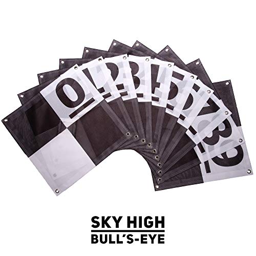
Finally a better alternative to homemade Ground Control Points (GCPs) to fulfill any UAV drone mapper’s needs. With a unique center passthrough design, this GCP can be used on already established survey points, which enables mapping to be performed after a surveyor has already taken coordinates. Simply place the survey marker through the 3″ x 3″ center cutout of the GCP to perform precise aerial mapping with pre-established coordinates. The GCP can also be used via a more traditional approach with the center flaps covering the cutout, enabling centimeter level precision mapping. The cutout flaps provides a center point to shoot your own coordinates, with an open center to place your rod, decreasing the chances of puncturing the GCP. The 24″ x 24″ design enables easy transport and storage of the GCPs as well as a scale to use when reconstructing your map. With 4 tie down points, the GCP is also easy to keep in position, even on the windiest of days. New for this iteration, a number system has been implemented for more efficiency in the field. With numbers 0-9 presented on one square of the target, users can easier identify their targets from the air. If needed, additional numbering or letting can be added in the other square using a permanent marker, which enables numbering from 0-99 if needed.
- Novel center cutout design enables easy mapping with pre-established survey markers
- 4 corner anchor points included to affix to ground
- Numbering to enable easy identification of targets
- Durable construction that will last for years
- Foldable and lightweight for easy transportation